
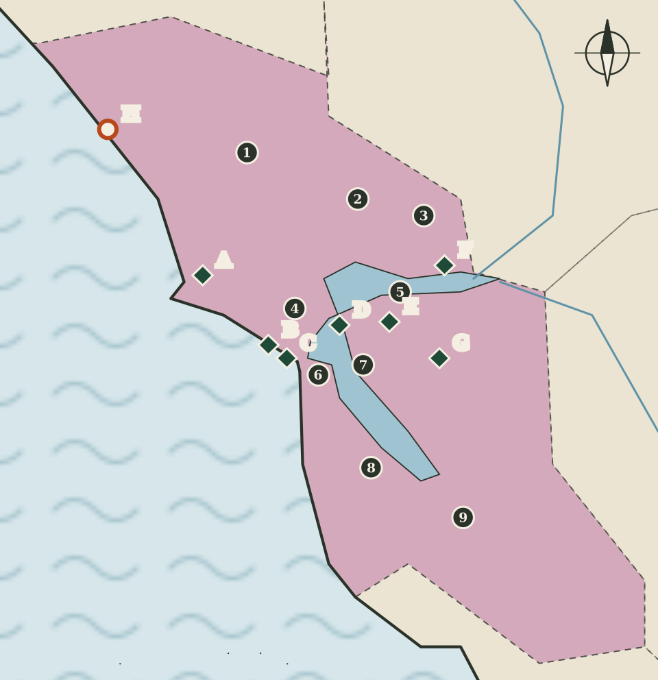
The region at a glance
The Bay Area is the most compact region in this atlas: nine counties wrapped around one body of water. On the map the bay is a simple blue shape opening to the ocean at the Golden Gate, and the region around it is shaded pink. The county seats sit close together on every shore, and so do the national park sites. No other region on these maps has as many National Park Service markers in so small an area.
That density is the main thing this page explains. Many of the sites are small, and several of them tell parts of the same story: how the entrance to the bay was guarded, how the region worked during the Second World War, and how the conservation movement grew up within sight of the city.
Nine counties and their seats
Seats are as listed by the California Secretary of State. For San Francisco, the county and its seat share the same name.
| Map | County | County seat |
|---|---|---|
| 1 | Sonoma | Santa Rosa |
| 2 | Napa | Napa |
| 3 | Solano | Fairfield |
| 4 | Marin | San Rafael |
| 5 | Contra Costa | Martinez |
| 6 | San Francisco | San Francisco |
| 7 | Alameda | Oakland |
| 8 | San Mateo | Redwood City |
| 9 | Santa Clara | San Jose |
Every seat is drawn as the same small dot, whatever the size of the city: the map shows where county government sits, not how many people live there.
The Golden Gate cluster
Marker C stands for a group of National Park Service sites on both sides of the Golden Gate, too close together to draw separately at this scale.
- Golden Gate National Recreation Area is the largest of them. The park service describes it as supporting 19 distinct ecosystems with more than 2,000 plant and animal species, and as holding centuries of overlapping history: California's indigenous cultures, Spanish colonialism, the Mexican Republic, United States military expansion and the growth of San Francisco.
- The Presidio of San Francisco served as an army post for three nations over 218 years, according to the park service. Its grounds include historic architecture, a national cemetery, a historic airfield, forests and beaches.
- Fort Point National Historic Site sits at the Presidio overlooking the Golden Gate. The park service says it defended the bay from the years after the Gold Rush through the Second World War, and it is known for its arched brick casemates beside the Golden Gate Bridge.
- Alcatraz Island was once a fort, then a military prison, then a maximum security federal penitentiary. In 1969 the Indians of All Tribes occupied the island for 19 months in the name of Native American civil rights, a chapter the park service presents alongside the prison history.
- San Francisco Maritime National Historical Park, established in 1988, is a 50-acre park around Aquatic Park Cove that tells the story of the city's seafaring past.
All five appear in the National Park Service's listing for California, under San Francisco. On the map, marker C is placed slightly west of the San Francisco seat dot so both can be read.
Marin: Muir Woods and Point Reyes
North of the Golden Gate, Marin County holds two of the region's best-known protected landscapes.
Muir Woods National Monument (marker B), listed under Mill Valley, protects old-growth coast redwoods growing along Redwood Creek. The park service notes that it has been federally protected as a national monument since 1908.
Point Reyes National Seashore (marker A) takes in ocean breakers, rocky headlands, long sand beaches, grasslands, brushy hillsides and forested ridges. The park service counts more than 1,500 species of plants and animals there and describes the seashore as home to several cultures over thousands of years.
East Bay: home front and naturalists
Along the eastern and northern shores of the bay, four national park sites tell stories from the late nineteenth and twentieth centuries.
Rosie the Riveter WWII Home Front
This national historical park in Richmond (marker D) honours the contributions and sacrifices of American civilians on the home front during the Second World War, and the different communities who lived and worked there.
Port Chicago Naval Magazine National Memorial
On July 17, 1944, two ships loading ammunition for troops in the Pacific exploded at Port Chicago (marker F), killing 320 men instantly. The National Park Service calls it the worst home front disaster of the war and notes that its aftermath brought the issues of segregation and racial inequality in the military into the open. The memorial lies within the Concord Naval Weapons Station.
John Muir National Historic Site
In Martinez, which is also the seat of Contra Costa County, the park service preserves the home of John Muir (marker E). It describes Muir as a fruit rancher, family man and writer, and as one of the country's most influential naturalists, whose advocacy helped protect wild places for future generations.
Eugene O'Neill National Historic Site
In Danville (marker G) is Tao House, where Eugene O'Neill, described by the park service as America's only Nobel Prize-winning playwright, wrote his final plays, including The Iceman Cometh, Long Day's Journey Into Night and A Moon for the Misbegotten.
Sonoma coast: Fort Ross
The one state park marker on this map (H) is Fort Ross State Historic Park on the Sonoma coast. California State Parks lists Fort Ross among the National Historic Landmarks in its care and describes it as the largest single Russian trading center outside Alaska. The State Parks website could not be reached for this atlas's automated check, so the page gives no further detail.
The Anza trail
The Juan Bautista de Anza National Historic Trail ends in San Francisco. The park service describes it as covering more than 1,200 miles through the homelands of more than 70 Tribal communities, following the route of the 1775 to 1776 Spanish colonizing expedition from Sonora, in Mexico, to San Francisco. The trail is not drawn, because it is a route rather than a place, but its southern sections pass through the Central Coast and Southern California regions too.
Reading the map
This map is cropped closer than the others, so the bay looks large and the counties look roomy. Even so, the markers around the Golden Gate overlap the seats, and several are nudged a little to keep the letters readable. The bay's outline is a simplified sketch that leaves out its smaller arms and islands. Use the map to see which shore each site is on, then use the National Park Service and California State Parks pages for directions and opening details.
Carry on to: The High Sierra and the East: from Yosemite to Death Valley