
The region at a glance
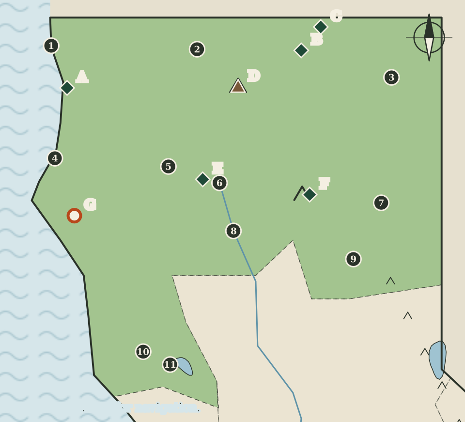
The Far North covers the top of the state: the Pacific coast at the Oregon line, the mountains behind it, the country around two volcanoes and the high northeast corner, reaching south as far as Mendocino and Lake counties. On the map it is drawn in green, with the Sacramento River entering from the north and two larger pen-drawn peaks marking Mount Shasta and Lassen Peak.
Three quite different stories sit side by side here. Along the coast are redwood forests protected by national and state parks. In the middle are two volcanoes that the US Geological Survey monitors and describes in detail. In the northeast are lava fields and the remains of a wartime incarceration camp. This page takes them in that order, after a short guide to the counties.
Eleven counties and their seats
The California Secretary of State lists the following seats for the eleven counties filed in this region. The numbers match the dots on the map, which run roughly from north to south and from west to east.
| Map | County | County seat |
|---|---|---|
| 1 | Del Norte | Crescent City |
| 2 | Siskiyou | Yreka |
| 3 | Modoc | Alturas |
| 4 | Humboldt | Eureka |
| 5 | Trinity | Weaverville |
| 6 | Shasta | Redding |
| 7 | Lassen | Susanville |
| 8 | Tehama | Red Bluff |
| 9 | Plumas | Quincy |
| 10 | Mendocino | Ukiah |
| 11 | Lake | Lakeport |
On the map, two seats sit on the coast (Crescent City and Eureka), two sit beside the blue line of the Sacramento River (Redding and Red Bluff), and the rest are scattered across the interior. The wide spaces between the dots are a reminder of how large several of these counties are compared with those around San Francisco Bay, where the next map but one packs nine seats into a much smaller area.
The redwood coast
The northernmost stretch of California's coast belongs to Redwood National and State Parks (marker A), which the National Park Service lists under Del Norte and Humboldt counties. The park service describes the area as renowned for the world's tallest trees, with landscapes that also take in open prairies, oak woodlands, rivers and an untamed coastline, and it notes that people have lived here for thousands of years. The parks are run as a partnership: the National Park Service and California State Parks work together to protect and restore the land. That is why the map uses a single national park marker for a place that also contains state parks.
Further south in Humboldt County lies Humboldt Redwoods State Park (marker G). California State Parks describes it as the state's largest redwood state park and the home of the Rockefeller Forest, a large stand of old-growth coast redwoods, with the scenic road known as the Avenue of the Giants running through it. The State Parks website could not be reached for this atlas's automated check, so this page keeps to that plain description and gives no acreage or road lengths.
The two parks show the same tree in two settings. Redwood National and State Parks reaches the open coast near Crescent City; Humboldt Redwoods lies inland along river valleys south of Eureka. On the drawing, both markers sit inside the green coastal strip west of the mountains.
Two volcanoes
The region's two great volcanoes, Mount Shasta and Lassen Peak, are drawn on the map with heavier strokes than the Sierra crest further south.
Mount Shasta
Mount Shasta (marker D) is a steep-sided stratovolcano in Siskiyou County, about 60 miles north of Redding along the Interstate 5 corridor. The US Geological Survey gives its height as 14,163 feet and calls it the most voluminous of all the Cascade Range volcanoes, meaning that it holds a greater volume of rock than any of the others. The towns of Weed, Mount Shasta and McCloud lie in its shadow.
According to the USGS, the present mountain grew on the remains of an older volcano that collapsed between 300,000 and 500,000 years ago, in one of the largest landslides known on Earth. Its most recent eruption was about 3,200 years ago. The survey rates its threat potential as very high, a judgement about what could happen in a future eruption rather than a report of current activity.
Lassen Peak
To the southeast, Lassen Volcanic National Park (marker F) surrounds Lassen Peak. The National Park Service lists the park under the small town of Mineral and describes steaming fumaroles, meadows of wildflowers, clear mountain lakes and numerous volcanoes, with hot water still shaping the land.
The USGS places the Lassen Volcanic Center in Shasta County and records three notable recent eruptions: Chaos Crags about 1,100 years ago, Cinder Cone in 1666, and Lassen Peak itself from 1914 to 1917. That last eruption was mostly a series of steam blasts, but in May 1915 molten rock began to build a lava dome in the vent. The survey gives Lassen Peak's elevation as 10,456 feet and describes a vigorous geothermal system with hot springs, steam vents and boiling mud pots.
Lava beds and Tule Lake
Close to the Oregon line, two national monuments share the town of Tulelake as their listed location.
Lava Beds National Monument (marker B) lies on the flank of the Medicine Lake shield volcano. The National Park Service explains that eruptions over the last half-million years built a rugged landscape of volcanic features, including more than 800 caves, and that the monument also protects Native American rock art sites, historic battlefields and campsites, and a high desert wilderness.
Tule Lake National Monument (marker C) tells a later and harder story. It includes the Tule Lake Segregation Center, which the park service describes as the largest and most controversial of the sites where Japanese Americans were incarcerated during the Second World War, and Camp Tulelake, which was first a Civilian Conservation Corps camp, then an additional place of detention for Japanese Americans, and finally a prisoner of war camp. Another site from the same history, Manzanar, is described on the High Sierra and the East page.
Whiskeytown and the upper river
West of Redding is Whiskeytown National Recreation Area (marker E). The National Park Service describes it as a 42,000-acre area around Whiskeytown Lake, with waterfalls, rugged trails, Gold Rush history and a landscape still recovering from fire.
Redding and Red Bluff both stand beside the Sacramento River, drawn in blue on the map as it runs south out of the mountains. The next region, the Sacramento Valley and Gold Country, picks up the river where this page leaves it and follows it to the state capital.
Reading the map
The map above is a drawing, not a survey. The coastline is simplified, the dashed line around the region follows county boundaries only roughly, and every dot and marker is placed by eye. Use it to see what lies near what: that Crescent City and Eureka are the coastal seats, that Mount Shasta stands between Yreka and Redding, and that the lava beds lie far to the north of Lassen. It gives no distances and should not be used to plan a route. For directions, road conditions, closures or fees, use the information published by the agency that manages each place.
Carry on to: The Sacramento Valley and Gold Country