
The region at a glance
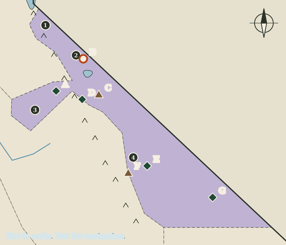
This region has the fewest counties in the atlas and some of its largest landscapes. Four counties lie along and beyond the crest of the Sierra Nevada: Alpine and Mono in the north, Mariposa reaching west toward the foothills, and Inyo stretching south and east to the Nevada line. On the map they are shaded lavender, and the small pen-drawn peaks of the Sierra crest run along their western edge.
Within this one region are the tallest mountain in the lower 48 states and the lowest point in North America, a famous national park, a gold-mining ghost town, a volcanic caldera and one of the camps where Japanese Americans were incarcerated during the Second World War. The page follows them roughly from north to south.
Four counties and their seats
Seats are as listed by the California Secretary of State.
| Map | County | County seat |
|---|---|---|
| 1 | Alpine | Markleeville |
| 2 | Mono | Bridgeport |
| 3 | Mariposa | Mariposa |
| 4 | Inyo | Independence |
Alpine County has no lettered landmark on this map. That is not a judgement about the county; it means none of the sources this atlas could check describes a national park site, state park or landform there. The same is true of several counties in other regions, and each page says so rather than filling the gap with unsourced detail.
Yosemite
Yosemite National Park (marker A) is listed by the National Park Service simply under the Sierra Nevada. The park service says it was first protected in 1864 and covers nearly 1,200 square miles, and that while it is best known for its waterfalls it also holds deep valleys, grand meadows, ancient giant sequoias and a vast wilderness. Its own short description speaks of the strength of granite and the power of glaciers.
On the map, Yosemite's marker sits near the eastern end of the Mariposa County lobe, close to the line with Tuolumne County in the Gold Country region. The park reaches across more than one county, and this atlas does not try to draw its boundary. The marker shows where the park lies in relation to the seats around it, nothing more.
Mono County: Bodie and Long Valley
Bodie
Bodie State Historic Park (marker B) lies near Bridgeport, the seat of Mono County. California State Parks describes Bodie as a gold-mining ghost town whose buildings are kept in a state of "arrested decay", meaning they are protected from further collapse but not restored to look new. State Parks also lists Bodie among the National Historic Landmarks in its care. Its website could not be reached for the automated check, so this page gives no dates or figures for the town.
Long Valley Caldera
Further south, Long Valley Caldera (marker C) is a volcanic depression east of the central Sierra Nevada, about 20 by 10 miles across, in Mono County. The US Geological Survey explains that it formed about 760,000 years ago in the Bishop Tuff eruption, which it describes as a supereruption. The nearest town in the survey's summary is Mammoth Lakes. The USGS rates the threat potential of the Long Valley area as very high, and it continues to monitor it.
A caldera is the large hollow left when the ground above a magma chamber collapses during a very big eruption. On a drawing at this scale it cannot be shown as a shape, so it appears as a single landform marker.
Devils Postpile
Devils Postpile National Monument (marker D) is listed by the National Park Service as being in the Sierra Nevada near Mammoth Lakes. It was established in 1911 by presidential proclamation and protects the Devils Postpile formation, which the park service ranks among the world's finest examples of columnar basalt, with columns up to 60 feet tall. The monument also protects the 101-foot Rainbow Falls. The marker is drawn just west of the Long Valley marker. The park service places the monument by its nearness to Mammoth Lakes rather than by county, and this atlas files it on this page for the same reason.
Manzanar and Mount Whitney
Manzanar
Manzanar National Historic Site (marker E) is listed under Independence, which is also the seat of Inyo County. The National Park Service explains that in 1942 the United States government ordered more than 110,000 men, women and children to leave their homes and detained them in remote, military-style camps. Manzanar War Relocation Center was one of ten such camps. Tule Lake, described on the Far North page, was another site in the same history.
Mount Whitney
Mount Whitney (marker F) is the tallest mountain in the lower 48 states. The National Park Service gives the summit elevation as 14,505 feet. It lies on the boundary between Sequoia National Park and Inyo National Forest, on the far eastern edge of the park, and a chain of mountains called the Great Western Divide hides it from the park's roads. The park service calls it the most frequently climbed peak in the Sierra Nevada and explains that a permit system is in place for hikers entering the Mount Whitney zone. Anyone thinking of the climb should start with the permit information from the agencies that manage it.
Death Valley and Badwater
Death Valley National Park (marker G) is listed by the National Park Service in both California and Nevada. The park service describes a below-sea-level basin where steady drought and record summer heat make a land of extremes, while snow can frost the high peaks in winter and rare rainstorms bring fields of wildflowers.
Its best-known spot is Badwater Basin, which the park service calls the lowest point in North America at 282 feet below sea level. The salt flats there cover nearly 200 square miles and are made mostly of sodium chloride, the same compound as table salt.
Mount Whitney and Badwater Basin are both drawn on this map. The National Park Service figures put the highest point in the lower 48 states and the lowest point in North America within the same region of this atlas; the drawing gives no sense of the real distance between them.
Reading the map
This region is long and thin on the ground, and the map squeezes it into a rectangle with neighbouring regions shown in grey. The Sierra crest is drawn as a row of small peaks to suggest the mountains, not to trace them. Lakes are simplified to rough ovals. Mountain and desert conditions change quickly and some roads close for the season, so for any visit use the current information published by the National Park Service, California State Parks and the other agencies that manage these places.
Carry on to: The San Joaquin Valley: the southern Central Valley and its mountain edge