
The region at a glance
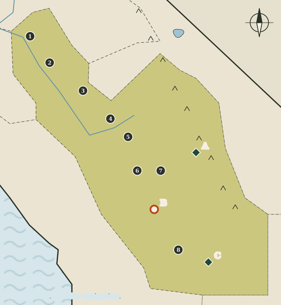
The San Joaquin Valley is the southern half of California's Central Valley, and on this map it is drawn as a long olive shape running from the Delta near Stockton down to Bakersfield. Its eight counties reach from the valley floor up into the southern Sierra Nevada in the east, so the region holds both farmland and high mountain parks.
The county seats line up down the middle of the valley like beads on a string. The landmarks are fewer and farther apart than in the Bay Area, but they cover a wide range: the giant sequoias of the southern Sierra, a town established by African American settlers, and a monument to the farm labour movement.
Eight counties and their seats
Seats are as listed by the California Secretary of State. On the map they run from north to south.
| Map | County | County seat |
|---|---|---|
| 1 | San Joaquin | Stockton |
| 2 | Stanislaus | Modesto |
| 3 | Merced | Merced |
| 4 | Madera | Madera |
| 5 | Fresno | Fresno |
| 6 | Kings | Hanford |
| 7 | Tulare | Visalia |
| 8 | Kern | Bakersfield |
Three of the eight counties, Merced, Madera and Fresno, share their name with their seat. San Joaquin County shares its name with the river and the valley instead. Hanford and Visalia, the seats of Kings and Tulare counties, are drawn close together in the south of the valley.
The valley floor and its water
The US Geological Survey describes the whole Central Valley as about 20,000 square miles of some of the most productive farmland in the world, growing more than 250 different crops. Its account of the San Joaquin Valley is mostly a story about water.
According to the survey, the San Joaquin Valley includes two basins: the San Joaquin Basin in the north and the Tulare Basin in the south. In the early 1960s, groundwater pumping drew water levels down to historic lows on the west side of the valley, and the land surface sank as a result, a process called subsidence. From the late 1960s, a surface-water delivery system began moving water from the wetter Sacramento Valley and the Delta to the drier, more heavily pumped San Joaquin Valley. Once that system was fully working in the early 1970s, groundwater levels recovered in the northern and western parts of the valley.
The Tulare Basin is different. The USGS calls it the hottest and driest part of the Central Valley and reports that it is still showing declines in groundwater levels and in stored groundwater. Hanford, Visalia and Bakersfield, the three southern dots on the map, sit in this part of the valley.
The San Joaquin River is drawn in blue, running west out of the mountains and then turning north to meet the Sacramento River near the Delta. The drawing leaves out canals, reservoirs and the many smaller rivers that cross the valley from the Sierra.
Sequoia and Kings Canyon
East of Visalia and Fresno on the map lies the southern Sierra Nevada. Sequoia and Kings Canyon National Parks (marker A) are listed by the National Park Service as lying in Tulare and Fresno counties. The park service describes huge mountains, rugged foothills, deep canyons, vast caverns and the world's largest trees, and warns that the ancient giant sequoias, invincible as they may seem, are vulnerable too.
The tallest mountain in the lower 48 states, Mount Whitney, stands on the far eastern boundary of Sequoia National Park, where the park meets Inyo National Forest. The park service notes that a chain of mountains called the Great Western Divide runs north to south through the centre of Sequoia and hides Mount Whitney from the park's roads. Whitney is drawn on the High Sierra and the East map, which covers the eastern side of the crest.
Allensworth
On the valley floor is Colonel Allensworth State Historic Park (marker B). California State Parks describes Allensworth as the only California town to be founded, financed and governed by African Americans. It was established in 1908 by Colonel Allen Allensworth and fellow settlers, and the state park now preserves the historic town site. The State Parks website could not be reached for this atlas's automated check, so this page gives no further figures about the town or the park.
The César E. Chávez monument
Southeast of Bakersfield on the map, César E. Chávez National Monument (marker C) has its mailing address at Keene. The National Park Service describes Chávez as widely recognised as the most important Latino leader in the United States during the twentieth century. He led farm workers and their supporters in establishing the country's first permanent agricultural union, and his leadership drew international attention to the conditions of farm workers and won them higher wages and safer working conditions. The monument includes the Nuestra Señora Reina de la Paz site.
Counties without a marker
San Joaquin, Stanislaus, Merced, Madera and Kings counties have no lettered landmark on this map. As on other pages, that reflects the limits of the sources this atlas could check, not the counties themselves. Each county's own government website and the California State Parks listing are the places to look for parks and historic sites within them.
Reading the map
The region's border is drawn by eye. On the west it follows county lines roughly; on the east it climbs toward the Sierra crest, which is suggested by a row of small peaks. The seats are placed by eye along the valley, and the three landmarks are well spread out, so nothing overlaps. Like every map on this site, it is not to scale and not for navigation; for travel into the mountains in particular, use the current conditions from the National Park Service.
Carry on to: The Central Coast: redwoods, spires and offshore islands