
The region at a glance
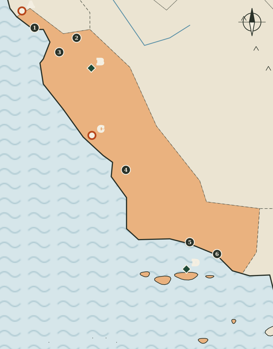
The Central Coast runs south from Santa Cruz to Ventura, between the Bay Area and Southern California. On the map it is a long apricot band along the ocean, widening inland in the middle, with a scatter of islands off its southern end. Six counties make up the region.
Its four landmarks are spread along its whole length and span very different kinds of public place: the first state park California created, a national park built on the remains of ancient volcanoes, a hilltop estate that is now a state historical monument, and a national park made of islands and the sea around them.
Six counties and their seats
Seats are as listed by the California Secretary of State.
| Map | County | County seat |
|---|---|---|
| 1 | Santa Cruz | Santa Cruz |
| 2 | San Benito | Hollister |
| 3 | Monterey | Salinas |
| 4 | San Luis Obispo | San Luis Obispo |
| 5 | Santa Barbara | Santa Barbara |
| 6 | Ventura | San Buenaventura (Ventura) |
Three of the six counties, Santa Cruz, San Luis Obispo and Santa Barbara, share their name with their seat. Ventura is a near case: the Secretary of State lists the seat under the city's formal name, San Buenaventura, while the county carries the shorter form that the city also goes by. Monterey County's seat is Salinas, inland from the coast, and San Benito County's seat is Hollister.
On the map, Santa Cruz, San Luis Obispo, Santa Barbara and Ventura are drawn at or near the shoreline, while Hollister and Salinas sit inland. The gaps between the dots are wide, especially between Salinas and San Luis Obispo, where the drawing shows only coast and hills.
Big Basin, the oldest state park
North of Santa Cruz on the map is Big Basin Redwoods State Park (marker A). California State Parks describes it as the state's oldest state park, established in 1902, and as a forest of ancient coast redwoods. It began under the name California Redwood Park, and its purchase is described by State Parks as the first successful effort to save coast redwoods from logging.
The park was badly damaged by the CZU Lightning Complex Fire in 2020 and reopened to visitors in stages afterward, according to State Parks. Facilities, trails and access have been changing during that recovery, so current visiting information is especially important here. The State Parks website could not be reached for this atlas's automated check, so this page gives no acreage or other figures.
Big Basin is one of four redwood landmarks in the atlas. Two of the others, Redwood National and State Parks and Humboldt Redwoods State Park, are on the Far North page, and Muir Woods is on the Bay Area page.
Pinnacles
Inland, east of Salinas and south of Hollister on the map, is Pinnacles National Park (marker B), which the National Park Service lists under Paicines. The park service explains that a series of volcanic eruptions around 23 million years ago shaped the land, and that their remains now form rocky spires and deep canyons. Visitors move between chaparral, oak woodland and the cool, shaded floors of the canyons.
Pinnacles is the only national park in this region that sits on the mainland. Its marker is drawn well away from the coast, which is the main thing the map can tell you about it: this is a park of inland hills and canyons, not of the shoreline.
Hearst San Simeon
On the coast of San Luis Obispo County, north of the county seat on the map, is Hearst San Simeon State Historical Monument (marker C). California State Parks describes the hilltop estate, also known as Hearst Castle, as the work of the architect Julia Morgan for William Randolph Hearst. The project began in 1919 as a request for a modest house and grew over the following decades into a large estate. The Hearst family and the Hearst Corporation later gave it to the state, and it is now run as a state historical monument.
The parks pages that describe the estate give different counts of its rooms and different years for the gift to the state, and the website could not be reached for an automated check, so this page gives neither.
The Channel Islands
Off the southern end of the region, Channel Islands National Park (marker D) is listed by the National Park Service under Ventura. The park service describes it as five islands together with their ocean environment. Isolation over thousands of years has produced animals, plants and archaeological resources found nowhere else on Earth, and the park offers a chance to see coastal southern California as it once was.
The map draws a row of small island shapes offshore. They are sketched for orientation only: their sizes and spacing are approximate, and the drawing does not show which islands belong to the national park. Two of the islands drawn further south are shaded as part of the Southern California region, because the atlas groups them with the counties on that page.
The Anza trail
The Juan Bautista de Anza National Historic Trail passes through this region on its way north to San Francisco. The National Park Service describes it as following the route of the 1775 to 1776 Spanish colonizing expedition from Sonora, in Mexico, to San Francisco, more than 1,200 miles through the homelands of more than 70 Tribal communities. It is a route, not a place, so it is not drawn on the map. The Bay Area page describes where it ends.
Reading the map
This is the tallest of the region maps, because the region is long from north to south. The coastline is simplified, the islands are rough ovals, and the region's inland border is drawn by eye along approximate county lines. The map is not to scale and not for navigation. Park access can change, so check the managing agency before any trip.
Carry on to: Southern California: six counties from the coast to the Colorado River