
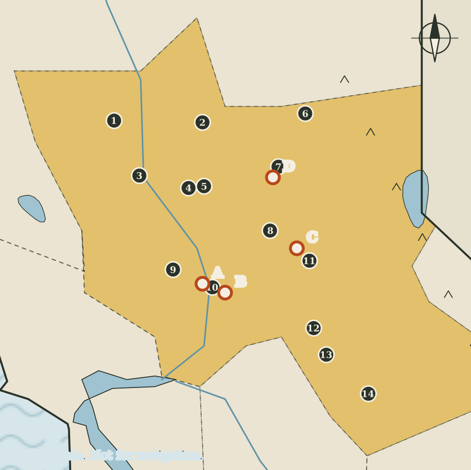
The region at a glance
This region joins two halves that belong together historically: the flat northern end of the Central Valley, and the foothills of the Sierra Nevada to its east, where gold was found in 1848. It holds fourteen counties, more than any other region in the atlas, and the state capital. On the map it is drawn in gold, with the Sacramento River running down its western side.
Read the map in two columns. The western column of dots follows the river and the valley floor, from Willows and Oroville in the north to Woodland and Sacramento in the south. The eastern column runs along the foothills, from Downieville and Nevada City down to Jackson, San Andreas and Sonora. The gold country markers sit in that eastern column.
Fourteen counties and their seats
Seats are as listed by the California Secretary of State. The map numbers run from north to south through the valley counties first, then through the foothill counties.
| Map | County | County seat |
|---|---|---|
| 1 | Glenn | Willows |
| 2 | Butte | Oroville |
| 3 | Colusa | Colusa |
| 4 | Sutter | Yuba City |
| 5 | Yuba | Marysville |
| 6 | Sierra | Downieville |
| 7 | Nevada | Nevada City |
| 8 | Placer | Auburn |
| 9 | Yolo | Woodland |
| 10 | Sacramento | Sacramento |
| 11 | El Dorado | Placerville |
| 12 | Amador | Jackson |
| 13 | Calaveras | San Andreas |
| 14 | Tuolumne | Sonora |
Two pairs of seats are so close that their dots almost touch on the drawing. Yuba City (Sutter County) and Marysville (Yuba County) are drawn almost on top of each other, and Sacramento shares its corner of the map with two landmark markers. Colusa is both a county and the name of its seat, as are Sacramento and, in other regions, several more.
The Sacramento Valley
The US Geological Survey treats the Central Valley as one great valley with two parts: the Sacramento Valley in the north, covered on this page, and the San Joaquin Valley in the south, covered on its own page. Together, the survey says, the Central Valley covers about 20,000 square miles and is one of the most productive agricultural regions in the world. More than 250 different crops are grown there, and roughly one-sixth of the nation's irrigated land lies within it.
Water is the thread that runs through the USGS account. The survey describes the Sacramento Valley as the wetter of the two halves: surface water is plentiful enough that less groundwater is pumped, and its groundwater storage has seen relatively little depletion. From the late 1960s, the surface-water delivery system began moving water from the Sacramento Valley and the Delta south to the drier, more heavily pumped San Joaquin Valley. On the map, the blue line of the Sacramento River runs down the west side of the gold-shaded region and meets the San Joaquin River near the edge of the Bay Area.
The valley seats on this page (Willows, Oroville, Colusa, Yuba City, Marysville and Woodland) are drawn in a loose line beside the river. The map does not attempt to show farmland, canals or reservoirs.
Sacramento: Capitol and fort
Sacramento is both the seat of Sacramento County and the home of the California State Capitol (marker A). The building is open to visitors as the State Capitol Museum, a state site that offers free tours of the historic Capitol building and of Capitol Park, along with exhibits on the history of the state and on the state symbols Californians have chosen over the last 150 years. Opening hours change, so check the museum's own page before a visit.
A short way across the city is Sutter's Fort State Historic Park (marker B). California State Parks lists the fort among the National Historic Landmarks in its care and describes it as the first pioneer settlement in Sacramento. On the map the two markers are drawn slightly apart so that both letters can be read; in reality they are much closer together than the drawing suggests.
Coloma and the gold discovery
East of Sacramento, in El Dorado County, is Marshall Gold Discovery State Historic Park (marker C) at Coloma. California State Parks places it on Highway 49 between Placerville and Auburn. The park marks the site where James Marshall found gold in January 1848 in the tailrace of Sutter's sawmill. The park includes a replica of the mill and the Marshall Monument, and State Parks says it is widening its interpretation beyond the moment of discovery, including formal consultation with tribes.
Coloma sits between two county seats on the map: Placerville to the south and Auburn to the north. The drawing does not show roads, so it cannot tell you how the towns are connected.
The foothill mining towns
North of Coloma, in Nevada County, is Empire Mine State Historic Park (marker D) at Grass Valley. California State Parks describes the Empire as one of the oldest and richest gold mines in California and records that it closed in 1956, more than a century after the Gold Rush began. The park also includes the mine owner's residence and gardens.
The other foothill seats on the map (Downieville, Nevada City, Auburn, Placerville, Jackson, San Andreas and Sonora) form a chain from north to south. This page does not describe each town's history, because the atlas cites only sources it could check, and none of those sources covers the towns individually. The chain itself is the useful thing the map shows: on paper, the gold country reads as a long, narrow belt of foothill towns rather than a single place.
Trails that ended here
Two of the national historic trails that the National Park Service administers end in or pass through this part of California, though neither is drawn on the map because they are routes rather than places.
- The California National Historic Trail follows the routes taken by more than 250,000 emigrants to the gold fields and farmlands of California in the 1840s and 1850s, which the park service calls the greatest mass migration in American history. The trail system is over 5,000 miles long and crosses parts of 10 states.
- The Pony Express National Historic Trail follows the relay route on which riders carried mail from Missouri to California in as little as 10 days, across eight states.
Reading the map
The gold region's border is drawn by eye along approximate county lines, the river is simplified to a single line, and the markers in Sacramento are spread apart for legibility. Use the map to see the shape of the region: a valley column and a foothill column, with the capital where the river turns toward the Delta. For directions and visiting information, use the pages of the State Capitol Museum and California State Parks.
Carry on to: The Bay Area: nine counties around one bay