
The region at a glance
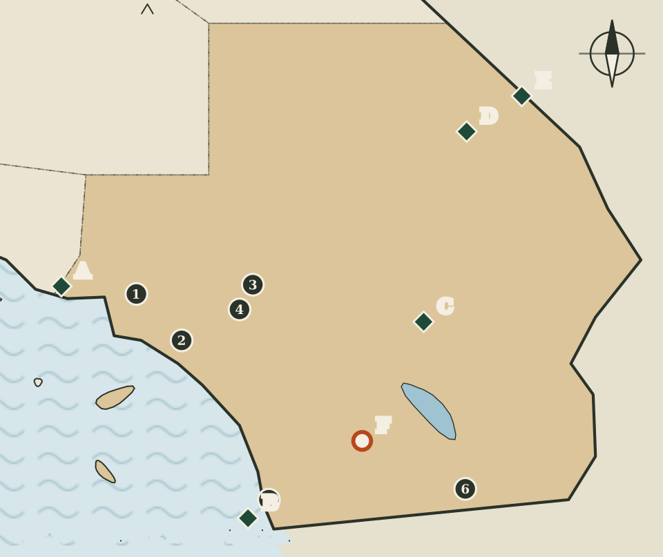
Southern California, as this atlas draws it, is six counties, filling the map from the Los Angeles coast east to the Colorado River and south to the Mexican border. On the map it is shaded sand-coloured, and it is a region of two halves. The county seats cluster in the west, close to the ocean; the national park sites are spread across the open desert to the east.
That split is the main thing the map shows. Five of the six seats sit in the western third of the drawing, while the eastern two-thirds hold a national park, a national preserve, a national monument and the largest state park in California, with only one county seat among them.
Six counties and their seats
Seats are as listed by the California Secretary of State.
| Map | County | County seat |
|---|---|---|
| 1 | Los Angeles | Los Angeles |
| 2 | Orange | Santa Ana |
| 3 | San Bernardino | San Bernardino |
| 4 | Riverside | Riverside |
| 5 | San Diego | San Diego |
| 6 | Imperial | El Centro |
Four of the six counties share their name with their seat. Orange County's seat is Santa Ana, and Imperial County's is El Centro, the one seat drawn in the desert southeast.
The Santa Monica Mountains
At the western edge of the region is Santa Monica Mountains National Recreation Area (marker A), which the National Park Service lists under Thousand Oaks. The park service describes it as offering easy access to surprisingly wild places, from the beaches of Malibu to more than 500 miles of trails, and as rich in historical and cultural sites, from old movie ranches to Native American centres.
The recreation area sits on the line between this region and the Central Coast, and its marker is drawn just inside Southern California. The atlas places it here because it lies beside Los Angeles on the map, not because of any county boundary.
Cabrillo's landing
At the far southwest corner, on the coast at San Diego, is Cabrillo National Monument (marker B). The National Park Service explains that in 1542 Juan Rodríguez Cabrillo came ashore here and became the first European to set foot on what is now the West Coast of the United States. The monument tells the story of that sixteenth-century exploration and also protects cultural and natural resources of its own. On the map its marker is drawn just southwest of the San Diego seat dot.
Two deserts: Joshua Tree
East of Riverside and San Bernardino lies Joshua Tree National Park (marker C). The National Park Service places it in southern California between Interstate 10 and Highway 62, with headquarters in Twentynine Palms. The park service explains that two distinct desert ecosystems, the Mojave and the Colorado, come together inside the park, and it describes a land sculpted by strong winds and occasional torrents of rain, with dark night skies, a rich cultural history and surreal geologic features.
The idea of two deserts meeting is a useful key to the whole eastern half of this map. The two national sites in the next section are both described by the park service as part of the Mojave Desert. For the other desert places on this map, the atlas does not say which desert they belong to, because its sources do not.
The Mojave preserve and Castle Mountains
In the northeast of the region is Mojave National Preserve (marker D). The National Park Service places it between Interstate 15 and Interstate 40, with headquarters in Barstow, and describes a mosaic of desert habitats and a history of human connection with the desert that goes back 10,000 years. The preserve is remote, and the park service presents it as a place of discovery and a connection to wild places.
Next to it is Castle Mountains National Monument (marker E). The park service describes it as nestled between the Nevada state line and Mojave National Preserve, nearly 21,000 acres of Joshua tree forest, unbroken natural landscape, rare desert grassland and human history.
On the map, both markers lie near the state's eastern edge, a long way from any county seat. The nearest seat dot, San Bernardino, is far to the west.
Anza-Borrego
In the south, between San Diego and El Centro on the map, is Anza-Borrego Desert State Park (marker F). California State Parks describes it as the largest state park in California. Its pages give more than one figure for its size, and the State Parks website could not be reached for this atlas's automated check, so this page gives no acreage. The Juan Bautista de Anza National Historic Trail, a separate route, is described on the Bay Area and Central Coast pages.
Old trails to Los Angeles
Two more national historic trails reach this region. Neither is drawn, because they are routes, not places.
- The Old Spanish National Historic Trail follows the routes of mule pack trains across the Southwest between Santa Fe, New Mexico, and Los Angeles, across what are now six states.
- The Butterfield Overland National Historic Trail follows a mail route that John Butterfield was contracted to run in 1857 between the eastern United States and the Far West. Its stagecoaches left twice a week, carrying passengers, freight and mail along an arc across the southern edge of the country.
Reading the map
The coast is simplified and the offshore islands are rough ovals; the two southern islands are shaded with this region. The large oval of water in the desert is drawn for orientation only. Dots and markers are placed by eye, and the county lines are not drawn at all. Desert travel needs current information on roads, heat and closures, so for any visit use the pages of the National Park Service and California State Parks rather than this drawing.
The tour of the regions ends here. Return to the 58 counties